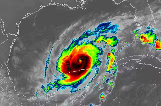
Less than two weeks after Hurricane Helene hit, Florida faced another big storm: Hurricane Milton. This hurricane strengthened into a Category 5 storm on Monday, October 7, intensifying explosively as its wind speeds grew by roughly 90 mph in about 25 hours. The storm intensified this fast because the waters in the Gulf of Mexico are record hot this year. Although Milton was expected to be Category 3, when it hit land, it still carried high winds and was predicted to raise water levels to 15 feet in Tampa Bay, Florida.
Forecasting Hurricane Milton
While Florida was still trying to recover from Hurricane Helene, roughly 15 million people were under flood watches, and there were 11 million at risk for tropical tornadoes. Thousands of people evacuated days before the hurricane hit. Milton had the potential to be one of the most destructive hurricanes on record for west-central Florida. Forecasters said that the winds at the center of the hurricane could weaken before it made landfall overnight on Wednesday, October 9, but that storm grew much larger, putting much of the Florida peninsula in danger.
The eastern side of the eye is considered the “dirty side” of the storm, where the winds will be the strongest. As the forecast track shifts northward, the dirty side falls over Tampa Bay. This will create a more severe hazard of storm surge in that confined area. “Even if it does weaken, you’re still looking at a major hurricane,” Florida Governor Ron DeSantis said. “It is going to have really, really significant impacts.”

Impacts and Aftermath of Hurricane Milton
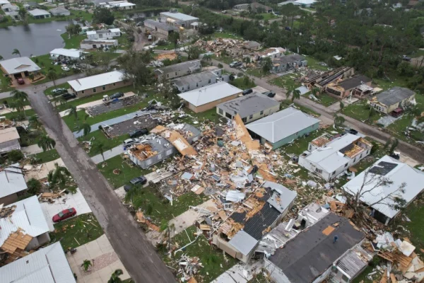
Hurricane Milton flooded neighborhoods, flattened homes, and knocked out power to millions of customers when it plowed through Florida on October 9th and 10th. The highest rainfall total was in St. Petersburg, Florida at 18.87 inches. The highest wind gust was 105 mph in Egmont Channel, Florida. The highest known storm surge was 5-6 feet in various spots in southwest Florida, including Naples and Fort Myers. There were also 126 tornado warnings issued. This is the highest number of tornado warnings issued in Florida in one day. Milton’s 180 mph winds made it one of only nine other Atlantic hurricanes to hit that wind threshold or higher. Its pressure dropped to 897 millibars, the lowest observed in any Atlantic hurricane since Wilma. That also ranks as the fifth-lowest pressure on record for any Atlantic hurricane.

Fortunately, they did not get the worst like they thought they would, but they did still get hit. The Tampa Bay region did not experience the disastrous storm surge that many forecasters had feared. There was serious flooding along the Gulf Coast, which received as much as 18 inches of rain. In St. Petersburg, winds gusting to more than 100 miles an hour tore part of the roof off Tropicana Field, the home stadium of the Tampa Bay Rays, and smashed a 500-foot construction crane onto a building housing the offices of The Tampa Bay Times.
Hopefully there will be no more hurricanes this year, because Florida has already been through enough. Now, people can finally start recovering and trying to get back to normal after probably one of the worst months of their lives.


